Overdue Road Tripping! Part 3
What about Part Two?
Eventually, after a long day with lots and lots of driving, we made it to our evening's destination, a cute Airbnb in Bakersfield, California. After unpacking and swapping out our hiking clothes for more suitable attire, it was time to head out to find some sustenance.
In last week's blog, Chris and I spent some time wandering the outdoors (at Red Rock Canyon National Conservation Area), watching the Super Bowl, and eating amazing food (at Bazaar Meat).
Visiting the lowest point in the Western Hemisphere
On Monday morning (Valentine's Day, for those of you keeping track), we woke up at the Signature by MGM in Las Vegas; we made ourselves another breakfast of granola, blueberries, and yogurt parfaits, and before too long, we were checking out and loading up the truck to head out of town. Following quick stops at the UPS Store to mail my fancy dresses back to the fine folks at Rent the Runway and a gas station to fill up the tank, it was out of the Vegas area for us, heading further northwest into a whole lot of nothingness toward our next destination - Death Valley National Park.
Some of the aforementioned nothingness -
aren't the erosion lines on the mountain cool?
Despite spending lots of time in the arid, hot southwest, and being acquainted with some folks in the ultrarunning community (technically, I'm an ultrarunner myself, having barely passed the lowest bar possible to be considered one, finishing just one 50K in my lifetime), we'd never made it to Death Valley. When our original trip plans had us traveling from Vegas to Paso Robles, California, I figured that while going through the park would add time and distance to our adventure, it would be well worth it.
From Vegas, we headed through Pahrump, Nevada, so we entered the park from the eastern edge, near the junction of the 190 and 127. From this side of things, Zabriskie Point was our first stop; Mr. Zabriskie was one of the muckety mucks for the Borax Company way back in the day, and while he was out in this area to oversee mining of the valuable mineral, he fell in love with this odd, harsh landscape. Understanding how important it was to protect this wilderness, he was one of the most strident early voices for declaring Death Valley a national treasure, and this sightseeing point, with incredible views into the Badlands area of the park, is named for him.
Reading the sign before heading up to the viewpoint
Death Valley is big - according to this rando website I found, it's the largest US national park in the lower 48 states - at 3.3 million acres, it's even bigger than Yellowstone! Because of that, it spans a wide array of climates, elevations, and biomes, and it has all sorts of different landscapes within its borders. While Zabriskie Point is the gateway to the Badlands area in the southeastern section of the park, there are tons of other things to see, so before too long, we were back in the truck, making our way to another section.
We hit the Furnace Creek Visitors Center (the largest in this area and one of the main ones in the park) around lunchtime, so after hitting the gift shop and buying a magnet, it was time to bust out our chicken salad wraps and grapes on a handy, nearby picnic table.
Although it was warm by February standards
(it was in the mid-80s for a high),
it wasn't that hot while we were eating lunch.
Thus, I'm not really sure what this face is for,
unless it's a reaction to me constantly taking pictures of our picnics.
Ooh, more new cooler glamour shots!
After cleaning up our lunch trash, it was back into the truck; we retraced our steps by just a few miles and headed south on Badwater Road, to one of the more famous locations within the park, Badwater Basin. On the way to the Basin, you pass the area known as the Devil's Golf Course, full of jagged salt spires eroded by wind and water.
This isn't the Golf Course itself,
but you can see some of the spires from the road.
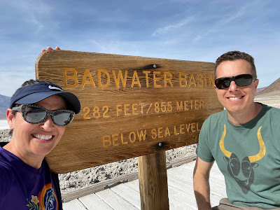
As you might have guessed by the salt spires on the way there, Badwater Basin is a massive stretch of salt flats; not only this, but it's also the lowest point in the Western hemisphere, clocking in at 282 feet below sea level.
It also gets very warm there.
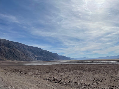
While the section of salt flat closest to the parking lot
is protected by the boardwalk,
eventually you just get out on the flats to stomp around.
The flats were a bit damp in spots while we were there
Stomping around
My watch, showing our elevation as negative 109 feet.
It's normally around 100 feet higher than the actual elevation,
so that's about right.
Chris is pointing at a sign on the mountain
that reads, "Sea Level."
Here, I'll help you find it:
We're probably a good 1/2 mile from the base
of that formation,
so that sign is a good ways above us.
Satisfied with the salt crust we'd accumulated on our boots and hiking pants, it was back into the truck once more to continue our driving tour of the park.
I am often reminded to "Make Good Choices"
by my husband, so I had to grab a shot of this sign.
Near the Stovepipe Wells Visitor Center, we passed the Mesquite Flat Sand Dunes. While they were cool, they weren't nearly as neat as White Sands, so we kept on driving.
Look how little and beige they are!
(Please excuse the "I obviously took this from the truck"
nature of this photo)
I zonked out in the passenger seat for a short while; apparently, while I was in dreamland, we gained quite a bit of elevation - up to about 5,000 feet or so (Telescope Peak, in the middle of Death Valley, tops out around 11,000 feet)! This place really has everything (including the Moving Rocks, which we didn't see - maybe next time)! After crossing the pass, we zoomed down through the Searles Valley, past Searles Lake, a dry lakebed where more borax mining and salt extraction used to occur. We also went through the city of Trona, where we were a bit spooked by its boarded up houses, broken windows, and almost total lack of humans; when we finally found cell service again (we were without it for most of the day, which was strange but also kind of nice?), we looked it up on Wikipedia - turns out, back in 2019, Trona was hit by two massive earthquakes, making almost everything in town unsafe. Most folks left (it was never a huge city to begin with) and moved to nearby Ridgecrest.
This is what most of Trona looks like right now -
we truly thought it was a 1920s mining boom town gone bust,
or that a meth crime ring took it over or something.
After passing through Trona, we continued on our odyssey of back roads through the desert, often seeing just one car every 20 minutes or so (this was the part where the lack of cell service was a little worrying). We were remote enough, and close enough to Edwards Air Force Base, that at one point in the afternoon, we had our own personal flyover from two fighter jets!
As we exited the freeway to our dinner location,
we happened to be directly across from the famous sign
(and Buck Owens' Crystal Palace, just to the right of this shot)
We ended up having Valentine's Day dinner at Temblor Brewing, just a few miles away from our Airbnb; we each grabbed a brew and burger, and we split some delicious fried artichoke hearts (why are these not a thing in more places? They were great)!
Noms!
Post-dinner, we relaxed at the Airbnb and did a small bit of re-packing and rearranging; we'd only be here for the night, and the next morning, it was on to Paso!
On the next blog, the wine tasting begins!
Later!
Amy


Comments
Post a Comment